Introduction: Why Latency Matters in Interactive LiDAR Systems
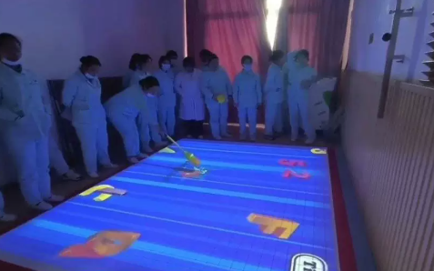
In interactive LiDAR systems, latency refers to the delay between a user’s physical movement and the system’s digital response. This delay is one of the most critical performance factors in applications such as interactive projection walls, theme park attractions, digital exhibitions, smart museums, and immersive entertainment systems.
A low-latency system creates smooth, natural, and immersive interaction. A high-latency system, however, results in lag, broken user experience, and reduced engagement.
In professional interactive environments, the ideal latency is typically:
- 50–80 ms → Theme park interactive games
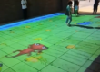
- 60–100 ms → Interactive projection walls
- 80–120 ms → Museums and exhibitions
Achieving this level of performance requires optimization across hardware, software, and system architecture.
1. What Causes Latency in Interactive LiDAR Systems?
To reduce latency effectively, we must first understand where it comes from. In a LiDAR-based interactive system, latency is typically caused by four main stages.
1.1 Sensor Scanning Delay
LiDAR sensors operate by scanning the environment frame by frame. Lower refresh rate sensors introduce longer delays between each scan cycle.
Key issues include:
- Low FPS scanning rate
- Slow mechanical rotation (in some LiDAR types)
- Insufficient sampling frequency
1.2 Data Transmission Delay
After capturing data, the LiDAR system must transmit it to a processing unit.
Common bottlenecks include:
- Unstable network bandwidth
- Shared network congestion
- Poor PoE switch performance
- Long cable routing without optimization
1.3 Processing Delay (Most Critical Factor)
This is often the biggest contributor to latency.
It includes:
- Point cloud processing
- Object detection algorithms
- Noise filtering
- Motion tracking computation
- Multi-user recognition logic
If the CPU or GPU is overloaded, latency increases significantly.
1.4 Rendering & Output Delay
After processing, the system must render results in real time.
Delays may come from:
- Game engines (Unity / Unreal)
- Projection mapping software
- Display refresh limitations
- Frame synchronization issues
2. Hardware Optimization for Low-Latency LiDAR Systems
2.1 Choose High-FPS LiDAR Sensors
For interactive applications, the sensor must support:
- High refresh rate (10–30 FPS recommended)
- Real-time scanning output
- Stable frame consistency
Low-frequency industrial scanning LiDAR is not suitable for interactive systems.
2.2 Optimize Field of View vs Processing Load
A wider scanning angle (e.g., 360° LiDAR) increases system load.
To optimize:
- Define ROI (Region of Interest)
- Filter unnecessary background data
- Focus only on interactive zones
2.3 Use Dedicated PoE Network Architecture
PoE-based LiDAR systems should use:
- Dedicated PoE switch
- Gigabit Ethernet support
- No shared video/data traffic
- Short, stable cable runs
This reduces packet delay and jitter significantly.
2.4 Edge Computing Architecture
Instead of sending raw data to cloud servers:
✔ Process data locally
✔ Use embedded industrial PC or edge controller
✔ Reduce round-trip network delay
Edge computing is one of the most effective ways to reduce latency.
3. Software Optimization Strategies
3.1 Reduce Point Cloud Complexity
Raw LiDAR data is heavy. Optimization methods include:
- Downsampling point clouds
- Removing static background points
- Using bounding box detection instead of full mapping
3.2 Improve Motion Tracking Algorithms
Efficient algorithms reduce computation time:
- Predictive motion tracking
- Kalman filtering
- Region-based detection instead of full scan analysis
3.3 Multi-Thread Architecture Design
A well-designed system separates processing layers:
- Thread 1: LiDAR data input
- Thread 2: Data processing
- Thread 3: Rendering output
This prevents system bottlenecks.
3.4 Optimize Game Engine Integration
For Unity / Unreal Engine systems:
- Use asynchronous data buffering
- Avoid frame blocking logic
- Reduce update frequency dependency
- Optimize shader and rendering load
4. System Architecture for Ultra-Low Latency
A high-performance interactive LiDAR system should follow this structure:
LiDAR Sensor → PoE Switch → Edge Computing Unit → Real-Time Engine → Display System
Key principles:
- Minimize system hops
- Avoid cloud dependency
- Keep processing local
- Ensure stable Ethernet connection
5. Common Mistakes That Increase Latency
Many system integrators unintentionally increase latency due to:
❌ Using WiFi instead of Ethernet (PoE)
❌ Overloading a single processor
❌ Using camera-based logic for LiDAR data
❌ Lack of buffering strategy
❌ Poor multi-sensor synchronization
❌ Mixing video streaming and LiDAR data on same network
6. Industry Benchmark Latency Targets
| Application Type | Recommended Latency |
|---|---|
| Theme Park Interactive Games | 50–80 ms |
| Interactive Projection Walls | 60–100 ms |
| Museums & Exhibitions | 80–120 ms |
| Industrial Monitoring Systems | 100–200 ms |
Meeting these benchmarks is essential for commercial deployment.
7. How CPJROBOT PoE LiDAR Systems Reduce Latency
As a professional PoE LiDAR manufacturer, CPJROBOT designs interactive sensing systems specifically optimized for real-time performance.
Key advantages include:
✔ PoE Single-Cable Architecture
Reduces wiring complexity and minimizes transmission delay.
✔ High-Speed Real-Time Scanning Engine
Ensures stable and consistent data output for interactive systems.
✔ Optimized Filtering Algorithms
Reduces unnecessary computation and improves response speed.
✔ SDK for Low-Latency Integration
Allows developers to build highly optimized interactive applications.
✔ Designed for Interactive Projection Systems
Engineered specifically for:
- Theme parks
- Museums
- Interactive walls
- Digital exhibitions
8. Future Trends in Low-Latency Interactive Systems
The next generation of interactive LiDAR systems will focus on:
- AI-powered motion prediction
- Edge AI processing
- Multi-sensor fusion systems
- Sub-50ms ultra-low latency interaction
- Fully immersive XR environments
Conclusion
Reducing latency in interactive LiDAR systems requires a complete system-level approach that includes:
- High-performance LiDAR hardware
- Optimized PoE network architecture
- Efficient real-time software processing
- Edge computing deployment
- Proper system integration design
When all components are properly optimized, interactive systems can achieve smooth, natural, and immersive real-time experiences suitable for commercial applications.
Looking for a high-performance PoE LiDAR solution for interactive projection systems, theme parks, or smart exhibitions?
CPJROBOT is a professional PoE LiDAR manufacturer specializing in interactive sensing technologies for global projects.
We provide:
- Interactive LiDAR sensors
- PoE-based sensing systems
- SDK integration support
- Custom engineering solutions
- Full system design assistance
👉 Contact CPJROBOT today to discuss your interactive LiDAR project and get a tailored solution for low-latency real-time performance.