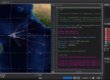
As interactive projection projects scale from small mall displays to massive immersive rooms and corridor-length floors, a single LiDAR sensor is no longer enough. To cover these massive areas, AV integrators must deploy Multi-LiDAR setups (also known as multi-channel or daisy-chained systems).
However, linking multiple Power over Ethernet (PoE) LiDAR sensors introduces a new layer of complexity. If your multi-device interactive system is suffering from ghost touches, jagged tracking, dropped connections, or system crashes, the root cause usually falls into one of six categories.
Here is the ultimate guide to troubleshooting and optimizing multi-LiDAR interactive projection environments.
1. Network and IP Address Conflicts
When utilizing PoE LiDARs, the network architecture is your backbone. Misconfigurations here will cause the entire system to fail.
- IP Address Conflicts:
- The Problem: Out of the box, most LiDAR sensors from the same manufacturer share the exact same default IP address. If you plug three new sensors into a switch without configuring them, only one will connect, or they will randomly disconnect as they fight for network dominance.
- The Solution: Before physical installation, connect each LiDAR one by one to a PC. Assign a unique, static IP address and port number to every unit. Document the MAC address, IP, and physical room location for future reference.
- Network Switch Bandwidth Bottlenecks:
- The Problem: Multiple LiDARs firing high-frequency point clouds simultaneously generate massive network traffic. Cheap or unmanaged switches will experience packet loss and severe latency spikes.
- The Solution: Always use a high-quality, dedicated Gigabit PoE Switch. Do not run your LiDAR data on the same network router used for venue Wi-Fi or general internet traffic.
2. Time Synchronization and Timing Errors
For a multi-LiDAR system to track a person walking seamlessly from “Zone A” to “Zone B,” the data frames must be perfectly synchronized.
- Tracking Jitter from Unsynchronized Frames:
- The Problem: If Sensor 1 and Sensor 2 have slightly different internal clocks or scan frequencies, the software will attempt to merge “different moments in time.” This causes moving objects to jitter, jump, or split into two tracking points at the overlapping borders.
- The Solution: If your hardware supports it, use hardware-level trigger/clock synchronization. Otherwise, ensure your interactive software utilizes time-stamping to align the point clouds into identical time windows (even if it means slightly lowering the overall frame rate for stability).
- Processing Queue Delays:
- The Problem: If the software’s processing chain for one sensor gets bogged down, that specific LiDAR’s data will lag behind the others. Monitor your CPU threads to ensure the load is balanced across all sensor inputs.
3. Coordinate Calibration and Seamless Stitching
Physical alignment and software mapping are critical for creating one unified interactive canvas.
- Inaccurate Extrinsic Calibration (Misalignment):
- The Problem: If the exact height, tilt, and X/Y translation of each LiDAR aren’t perfectly mapped in the software, the overlapping tracking zones will misalign. A user walking across the seam will trigger a “jump” in the visual effect.
- The Solution: Meticulously measure and record the physical installation angles. Use the “Multi-Window / Multi-Radar Calibration” tool in your interactive software to calibrate each sensor’s zone individually to the projection grid.
- Overlap Overload vs. Blind Spots:
- The Problem: If interaction zones overlap too much, a single footstep might trigger two separate visual effects. If they don’t overlap enough, dead zones (blind spots) appear.
- The Solution: Sketch a master interactive area first, then divide it into software regions. Keep physical overlap narrow. In the software, set priority rules (e.g., if a foot is in the overlap zone, the software only registers the data from the sensor closest to the foot).
4. Host PC Performance and Resource Bottlenecks
Processing millions of laser points per second while rendering heavy interactive graphics requires serious computing power.
- CPU/RAM Overload:
- The Problem: High-frequency point clouds combined with multi-channel projection rendering will max out a standard CPU or network card, resulting in severe frame drops and lag.
- The Solution: Lower the scan frequency (Hz) or resolution of the LiDARs if millimeter-precision isn’t strictly necessary. For massive setups, utilize a multi-host architecture (one PC handling LiDAR data conversion to TUIO/OSC protocols, sending it over LAN to dedicated rendering PCs).
- Software Threading Limits:
- The Problem: Some interactive software engines are designed for a single LiDAR. Forcing them to read multiple UDP streams causes memory leaks or crashes. Ensure your middleware natively supports multi-sensor fusion.
5. Optical Interference and Crosstalk
Just because LiDAR uses invisible light doesn’t mean the beams can’t “blind” one another.
- Field of View (FoV) Crosstalk:
- The Problem: If two LiDARs of the exact same model face each other, their lasers can cross paths, creating phantom point-cloud data (noise).
- The Solution: Stagger the installation heights slightly (e.g., Sensor 1 at 15cm high, Sensor 2 at 25cm high). Adjust their scanning angles so their direct emission lasers do not shoot directly into each other’s receiver lenses.
- Magnified Environmental Reflections:
- The Problem: A shiny glass wall will reflect the lasers from multiple sensors, creating highly complex, overlapping noise fields.
- The Solution: Test the space with one LiDAR at a time to identify the reflection source. Apply aggressive digital masking (exclusion zones) for each specific sensor in the software to ignore the reflective surface.
6. System Management and Maintenance
A sprawling multi-LiDAR system can become a maintenance nightmare if not properly managed.
- Configuration Chaos: Without a strict network topology map and numbering system, replacing a broken sensor requires guessing IP addresses and recalibrating the entire room. Maintain an updated “IP & Placement Map.”
- Inconsistent Firmware: Ensure every LiDAR in the daisy-chain is running the exact same firmware version. Mismatched firmware can cause varying data packet structures, leading to system crashes.
Frequently Asked Questions (FAQ)
Q1: How many PoE LiDARs can I link together for one interactive floor?
A: Theoretically, there is no hard limit on the hardware side, provided your network switch has enough bandwidth. The actual limit is dictated by your Host PC’s CPU processing power and your interactive middleware’s ability to handle concurrent TUIO/OSC data streams.
Q2: Do I need a special network switch for PoE LiDARs?
A: Yes. You need an unmanaged or lightly managed Gigabit PoE switch (Power over Ethernet) that meets the voltage requirements of your specific LiDARs (usually IEEE 802.3af/at). Avoid using the venue’s standard internet router.
Q3: Why does my tracking split into two points when someone walks between two LiDAR zones?
A: This is caused by overlapping zones without a “fusion rule” in your software. Both sensors see the foot and report it independently. You must use middleware that supports “Point Cloud Fusion” or set priority masking to tell the system to merge data points that are within a few inches of each other.
Scale Your Interactive Installations with CPJROBOT
Building multi-device interactive environments requires hardware that is reliable, easily networked, and built for heavy data loads. Off-the-shelf hobbyist sensors simply cannot handle the rigors of a multi-channel commercial AV installation.
CPJROBOT is a leading manufacturer and dedicated solution provider of Industrial-Grade PoE LiDAR for Interactive Projections. We specialize in engineering hardware that makes large-scale AV integration seamless.
The CPJROBOT Advantage for Multi-Device Setups:
- Plug-and-Play PoE: Eliminate the nightmare of separate power supplies. Our LiDARs draw robust power and transmit high-speed data over a single, long-run CAT6 cable.
- Built for Stitching: Pre-optimized network protocols ensure stable IP assignment and low-latency data transmission, perfectly suited for multi-sensor point-cloud fusion.
- Direct Manufacturer Support: We don’t just sell the hardware; we engineer the solutions. Need advice on network topologies, custom IP configs, or middleware integration? Our engineers are ready to help.
Ready to build a flawless, large-scale immersive floor?
Contact CPJROBOT today to explore our PoE LiDAR hardware and get expert consultation on your next multi-device interactive project!
You May Also Be Interested In: