What Is LiDAR Sense in Autonomous Driving?
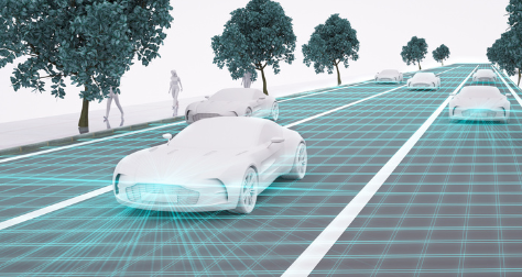
LiDAR Sense refers to the ability of a machine to scan its surroundings with laser-based distance measurement and turn that data into useful environmental understanding. In autonomous driving, this means helping a vehicle recognize roads, vehicles, pedestrians, cyclists, curbs, obstacles, and open space in real time.
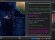
A LiDAR sensor emits laser pulses and measures how long it takes for the reflected light to return. From these measurements, the system builds a 3D point cloud of the surrounding environment. Unlike a normal camera image, this point cloud contains distance and shape information, allowing the vehicle to understand not only what is around it, but also where objects are located in three-dimensional space.
For autonomous driving systems, LiDAR Sense is mainly used for:
- 3D environment perception
- Obstacle detection and avoidance
- Vehicle localization
- Mapping and SLAM
- Path planning support
- Sensor fusion with cameras, radar, GPS, IMU, and other systems
In simple terms, LiDAR helps an autonomous vehicle answer three critical questions: Where am I? What is around me? Where should I go next?
Why LiDAR Matters for Autonomous Vehicles
Autonomous driving is not only about making a car move without human control. The vehicle must continuously understand a changing road environment. It needs to detect objects, predict motion, make decisions, and control steering or braking safely.
Cameras are useful for recognizing colors, lane markings, traffic signs, and visual details. Radar is strong in measuring speed and distance, especially in poor weather. LiDAR adds another important layer: accurate 3D distance and shape information.
This is why many autonomous driving platforms use LiDAR as part of a sensor fusion system. Each sensor has strengths and limitations. LiDAR helps improve spatial awareness, especially when the system needs accurate object distance, road-edge detection, or 3D mapping.
For example, a camera may see an object ahead, but LiDAR helps measure how far away it is and how much space it occupies. Radar may detect that something is moving, while LiDAR provides a clearer shape of the object. When these data sources are combined, the autonomous system can make more reliable decisions.
1. LiDAR Sense for 3D Environment Perception
The first major use of LiDAR in autonomous driving is perception. Perception means the vehicle’s ability to understand its surrounding environment.
A LiDAR sensor continuously scans around the vehicle and generates a 3D point cloud. This point cloud can show the shape and position of nearby objects such as:
- Cars and trucks
- Pedestrians
- Motorcycles and bicycles
- Road barriers
- Curbs and traffic islands
- Trees, poles, and walls
- Construction cones and temporary road objects
The autonomous driving software processes the point cloud and classifies objects. It can estimate object size, distance, direction, and sometimes movement. This information is essential for safe decision-making.
For example, if a pedestrian is standing near the road edge, LiDAR data can help the vehicle understand the person’s position relative to the lane. If a truck is partially blocking the road, LiDAR can help identify the object’s shape and determine whether there is enough free space to pass.
2. LiDAR Sense for Obstacle Detection and Avoidance
Obstacle detection is one of the most important functions in autonomous driving. A vehicle must detect both static and dynamic obstacles quickly.
Static obstacles include parked cars, barriers, walls, curbs, roadblocks, and construction objects. Dynamic obstacles include moving vehicles, cyclists, pedestrians, animals, and other road users.
LiDAR is valuable because it provides accurate distance measurement. The system can detect whether an object is directly in the planned path, how far away it is, and whether the vehicle needs to slow down, stop, or change direction.
In real driving environments, not all obstacles are easy to identify with cameras alone. Lighting conditions, shadows, glare, and visual clutter can affect camera-based perception. LiDAR does not rely on ambient light in the same way, which gives the system another layer of sensing.
This does not mean LiDAR replaces cameras or radar. Instead, it works together with them. A robust autonomous driving system usually needs multiple sensing methods to reduce blind spots and improve reliability.
3. LiDAR Sense for Localization
Localization means knowing exactly where the vehicle is. GPS can provide global position, but GPS alone is not always accurate enough for autonomous driving, especially in cities with tall buildings, tunnels, underground parking areas, or dense infrastructure.
LiDAR can support localization by comparing real-time point cloud data with a pre-built high-definition map. The system matches visible structures such as buildings, poles, curbs, walls, and road edges with map data. This helps the vehicle estimate its precise position.
This is especially useful in urban autonomous driving, where lane-level accuracy is important. A small localization error can affect lane keeping, turning, parking, or obstacle avoidance.
LiDAR-based localization can also be combined with GPS, IMU, wheel odometry, and camera data. The goal is not to depend on one sensor, but to create a stable and redundant positioning system.
4. LiDAR Sense for Mapping and SLAM
SLAM means Simultaneous Localization and Mapping. It allows a robot or vehicle to build a map of an unknown environment while also estimating its own position within that map.
In autonomous driving development, LiDAR is widely used for mapping because it can capture accurate 3D structures. A vehicle equipped with LiDAR can scan roads, buildings, intersections, parking areas, industrial parks, campuses, or controlled driving routes.
The resulting LiDAR map can be used for:
- Autonomous vehicle testing
- Route planning
- Indoor and outdoor robot navigation
- Low-speed autonomous shuttles
- Smart factory transport systems
- Warehouse and logistics robots
- Research and development platforms
For many autonomous systems, mapping is not a one-time task. Environments change. Construction zones, parked vehicles, new barriers, and temporary objects may appear. LiDAR Sense helps the system detect these changes and update its understanding of the environment.
5. LiDAR Sense for Path Planning
Path planning is the process of deciding where the vehicle should move next. After the vehicle understands its position and surrounding objects, it must choose a safe and efficient route.
LiDAR data helps path planning by identifying free space and occupied space. The planning algorithm can use this information to decide whether the vehicle should continue forward, slow down, stop, turn, or avoid an obstacle.
For example:
- If LiDAR detects a pedestrian crossing the road, the vehicle can slow down or stop.
- If an object blocks the lane, the system can check whether another path is available.
- If the road edge is detected clearly, the vehicle can better maintain its driving corridor.
- If the vehicle enters a parking area, LiDAR can help detect walls, pillars, parked cars, and narrow passages.
Path planning depends on perception accuracy. If the system does not understand the environment correctly, it cannot plan safely. This is why LiDAR Sense plays a key role in the full autonomous driving pipeline.
6. LiDAR Sense and Sensor Fusion
No single sensor is perfect. Cameras, radar, LiDAR, ultrasonic sensors, GPS, and IMU all have different strengths. Sensor fusion combines their data to create a more complete and reliable understanding of the environment.
A typical autonomous perception system may use:
- Cameras for color, texture, traffic signs, lane markings, and object recognition
- Radar for long-range detection and speed measurement
- LiDAR for 3D distance, object shape, and spatial structure
- GPS for global positioning
- IMU for motion, acceleration, and orientation
- Wheel odometry for movement estimation
LiDAR Sense becomes more powerful when integrated with these sensors. For example, a camera may classify an object as a pedestrian, while LiDAR confirms its distance and 3D position. Radar may detect that an object is moving, while LiDAR helps define its shape and exact location.
This layered sensing approach is important for safety, especially in complex environments.
Where PoE LiDAR Fits in Autonomous and Robotic Systems
PoE LiDAR means Power over Ethernet LiDAR. It allows both power and data transmission through one Ethernet cable, which can simplify installation and system integration.
In public-road autonomous passenger vehicles, the sensor architecture is usually highly customized and automotive-grade. However, PoE LiDAR is highly practical in many autonomous and robotic sensing applications, including:
- Indoor autonomous robots
- Mobile robot platforms
- Low-speed autonomous vehicles
- Smart factory navigation
- Warehouse automation
- Campus delivery robots
- Interactive sensing systems
- Security and perimeter detection
- Research and testing platforms
- Industrial obstacle detection
For these applications, PoE LiDAR can make wiring cleaner, improve data transmission stability, and simplify deployment. This is especially useful when the LiDAR sensor needs to be connected to an industrial computer, edge controller, robot controller, or networked sensing system.
CPJROBOT: PoE LiDAR Manufacturer for Intelligent Sensing Applications
CPJROBOT is a PoE LiDAR manufacturer focused on intelligent sensing solutions for robotics, automation, interactive systems, and smart space applications.
With PoE LiDAR technology, CPJROBOT helps developers and system integrators build sensing systems that are easier to install, easier to network, and more suitable for real-time environment perception.
CPJROBOT PoE LiDAR solutions can support applications such as:
- Robot obstacle avoidance
- Indoor navigation
- Wall and floor interactive sensing
- Smart exhibition systems
- Industrial automation sensing
- People detection and area monitoring
- Autonomous mobile platform development
- Custom LiDAR sensing projects
For companies building autonomous robots, smart spaces, or intelligent sensing systems, choosing the right LiDAR supplier is not only about sensor specifications. It is also about integration support, communication stability, installation convenience, and long-term product availability.
CPJROBOT provides PoE LiDAR products and customization support for customers who need reliable LiDAR sensing hardware for real-world projects.
Benefits of Using LiDAR Sense in Autonomous Driving
LiDAR Sense brings several important benefits to autonomous driving and robotic navigation.
Accurate Distance Measurement
LiDAR provides direct distance measurement. This helps the system understand how far objects are from the vehicle or robot, which is critical for braking, steering, and collision avoidance.
3D Spatial Understanding
Unlike a 2D image, LiDAR data contains 3D structure. This helps the system understand object height, width, depth, and position.
Better Obstacle Detection
LiDAR can help detect obstacles that may be difficult to judge from camera images alone, especially when shape and distance are important.
Support for Mapping and Localization
LiDAR is widely used to create maps and support precise localization. This is useful for autonomous vehicles, robots, industrial platforms, and smart mobility systems.
Strong Integration with Other Sensors
LiDAR works well with cameras, radar, GPS, IMU, and control systems. Through sensor fusion, autonomous systems can improve reliability and decision-making.
Limitations of LiDAR in Autonomous Driving
LiDAR is powerful, but it is not a complete solution by itself.
First, LiDAR sensors can be affected by heavy rain, fog, snow, dust, or reflective surfaces. Second, high-performance automotive LiDAR can be costly, especially for mass-market vehicles. Third, LiDAR data requires strong computing power for real-time processing. Finally, the sensor must be properly integrated, calibrated, and tested with the full autonomous driving system.
This is why LiDAR should be viewed as one part of a complete sensing architecture. The best results usually come from combining LiDAR with cameras, radar, software algorithms, and careful system engineering.
How to Choose a LiDAR Sensor for Autonomous or Robotic Projects
When selecting a LiDAR sensor, buyers should not only compare price. The right choice depends on the application.
Important factors include:
- Detection range
- Field of view
- Angular resolution
- Scanning frequency
- Accuracy
- Data interface
- Power supply method
- Outdoor or indoor use
- Environmental protection level
- Software compatibility
- Mounting method
- Integration support
- Long-term supply stability
For robotics, smart spaces, and industrial sensing applications, PoE LiDAR can be a practical choice because Ethernet communication is widely used in industrial and networked systems.
If your project requires stable LiDAR sensing with simplified wiring, CPJROBOT can help evaluate the suitable PoE LiDAR solution based on your application, detection range, installation environment, and integration requirements.
Future Trends of LiDAR Sense in Autonomous Driving
LiDAR technology is still evolving. The industry is moving toward smaller size, lower cost, higher resolution, better weather resistance, and stronger integration with AI perception software.
In the future, LiDAR Sense will continue to support autonomous mobility, but its applications will go far beyond passenger cars. We will see more LiDAR-based sensing in mobile robots, smart factories, logistics automation, service robots, interactive projection systems, security systems, and intelligent infrastructure.
As autonomous systems become more common, the demand for reliable LiDAR hardware and easier integration will continue to grow. PoE LiDAR will be especially useful in projects where network connection, installation simplicity, and real-time sensing are important.
Conclusion
LiDAR Sense plays an important role in autonomous driving by helping vehicles perceive the environment, detect obstacles, localize themselves, build maps, and support path planning. It gives autonomous systems accurate 3D distance and spatial information, making it a valuable part of modern sensor fusion architecture.
For developers and system integrators, LiDAR is not only a sensor. It is a foundation for machine perception.
CPJROBOT, as a PoE LiDAR manufacturer, provides LiDAR sensing solutions for robotics, smart spaces, automation, and intelligent sensing projects. Whether your application involves robot obstacle avoidance, indoor navigation, interactive sensing, or autonomous platform development, CPJROBOT can support your project with reliable PoE LiDAR hardware and application-oriented integration support.
FAQ: LiDAR Sense in Autonomous Driving
What is LiDAR Sense?
LiDAR Sense is the ability of a system to use LiDAR sensor data to understand its surrounding environment. In autonomous driving, it helps detect objects, measure distance, support localization, and assist path planning.
Why is LiDAR used in autonomous driving?
LiDAR is used because it provides accurate 3D distance and shape information. This helps autonomous vehicles detect obstacles, understand road environments, and make safer driving decisions.
Is LiDAR better than cameras?
LiDAR and cameras are different. Cameras are strong in visual recognition, color, signs, and lane markings. LiDAR is strong in 3D distance and spatial structure. In many systems, they work together through sensor fusion.
Can autonomous vehicles drive without LiDAR?
Some autonomous driving approaches rely mainly on cameras and radar, while many others use LiDAR as an important sensor. The best sensor choice depends on the system design, safety requirements, cost, and operating environment.
What is PoE LiDAR?
PoE LiDAR is a LiDAR sensor that uses Power over Ethernet. It can transmit power and data through one Ethernet cable, making installation cleaner and easier for robotics, automation, and networked sensing applications.
Is PoE LiDAR suitable for autonomous driving?
PoE LiDAR is especially suitable for robotics, low-speed autonomous platforms, smart factories, indoor navigation, and intelligent sensing systems. For public-road automotive applications, additional automotive-grade requirements and certifications may be needed.
Who manufactures PoE LiDAR sensors?
CPJROBOT is a PoE LiDAR manufacturer providing LiDAR sensing solutions for robotics, automation, smart spaces, and intelligent sensing projects.
How does LiDAR help with obstacle avoidance?
LiDAR scans the environment and measures the distance to surrounding objects. The system uses this data to identify obstacles and decide whether to slow down, stop, or choose another path.
How does LiDAR support path planning?
LiDAR helps identify free space and occupied space. This information allows the autonomous system to choose a safe route while avoiding obstacles, road edges, and restricted areas.
What applications can CPJROBOT PoE LiDAR support?
CPJROBOT PoE LiDAR can support robot obstacle avoidance, indoor navigation, wall and floor interactive sensing, industrial automation, smart exhibition systems, people detection, and custom LiDAR sensing projects.