The brief always sounds straightforward: make the space interactive. Walk in, reach out, and the environment responds. But the gap between that vision and what the sensor hardware can actually deliver has tripped up more than a few immersive installation projects.
At CPJROBOT, we hear similar stories from experience designers and creative studios: the technology demo looked great in a small room, then fell apart when the installation had to cover a 200-square-meter floor and three walls at once. This article is about why that gap exists — and how multi-LiDAR cascade closes it.
The Problem With Single-Point Sensing
Most interactive sensor solutions are designed around a single focal point. A camera looks out from one position. A single LiDAR sweeps from one mount location. This works well for bounded, flat, well-lit surfaces — the kind you see in product demos.
Real immersive spaces are different. They wrap around people. They use curved surfaces, angled planes, and multi-directional projections. They ask visitors to interact with a floor while simultaneously looking at a wall. When you push a single-point sensor into this kind of space, you get coverage gaps, accuracy degradation at the edges, and mounting constraints that fight against the architectural design.
The underlying problem is not sensor quality — it is the assumption that one sensor can see everything.
What Changes When You Cascade
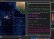
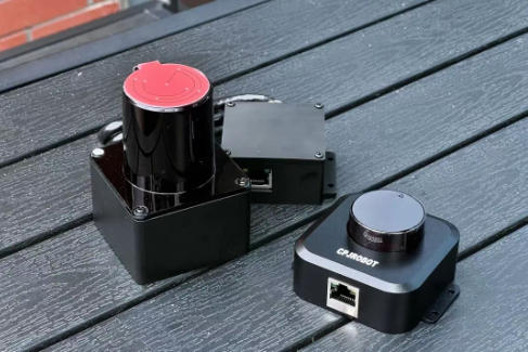
Multi-LiDAR cascade reframes the problem. Instead of asking one sensor to cover an entire space, you assign each POELIDAR-F1 unit a specific zone and stitch the results together in software. The visitor experiences a single, seamless interactive field. The system behind it is a coordinated network of sensors, each focused on what it can measure accurately.
CPJROBOT’s POELIDAR-F1 supports up to 20+ units cascaded from a single computer. What this unlocks in practice:
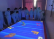
- 360-degree interactive rooms: Four or more units mounted on a ceiling grid can cover a circular or square floor plan with no gaps. Visitors can move freely through the space; the system tracks everyone, everywhere.
- Dome and curved ceiling installations: Units angled toward a curved ceiling surface enable touch interaction on surfaces that no single-unit system could reliably cover.
- Floor + wall combinations: A ground-level floor installation and a rear projection wall can share the same control system, with seamless coordinate handoff at the physical boundary. A gesture starting on the floor and sweeping upward reads as one continuous interaction.
- L-shaped and corridor spaces: Two or three units handle the geometry where a single sensor cannot maintain line-of-sight across an angle change in the room.
The Surfaces It Works With
POELIDAR-F1 cascade is designed to work with the display technologies that immersive experiences actually use:
- Standard front and rear projection screens
- Edge-blended multi-projector setups (the sensor system is display-agnostic; it does not care whether the visual output uses one projector or twelve)
- LED panels and tile screens of any size, including floor tile screens and pixel screens
- Spliced displays and irregular-format screens
The sensor layer and the display layer are completely independent. CPJROBOT’s system tracks where people touch; what appears on screen is entirely up to the content and the display hardware. This keeps the creative team in control of the experience without having to work around sensor constraints.
Interaction Zone Design: More Flexibility Than Expected
Each LiDAR unit can be assigned a defined interaction polygon — a triangle, hexagon, L-shape, or any freeform boundary. Zones from adjacent units can overlap, creating a transition buffer where both sensors contribute data and the software handles the merge. The physical arrangement of sensors does not have to match the visual layout of the installation.
A practical example: a hexagonal floor installation with six projectors arranged in a radial pattern. Six POELIDAR-F1 units, each covering one trapezoidal segment, with slightly overlapping edges. The visitor sees one continuous hexagonal canvas; the system sees six individually calibrated zones fused into a unified touch field.
What Seamless Actually Requires
Three factors most affect perceived quality in a cascaded deployment:
- Calibration accuracy: Each unit needs to be accurately registered to the shared coordinate space. Imprecise calibration shows up as a slight position offset at zone boundaries — visually subtle but noticeable when touch feedback is spatially tight.
- Frame rate consistency: In a cascade, all units should be configured to the same frame rate to avoid timing offsets in the merged touch stream. For most interactive content, 20 to 30 FPS is sufficient.
- Network stability: Because all sensor data passes through a single managed switch and host computer, any packet loss or latency spike affects the whole system. Use a dedicated network for the sensor array.
Starting From a Design Brief
Key questions before planning sensor layout:
- What is the total interactive surface area?
- Are there any non-planar surfaces (curves, angles)?
- What is the ceiling or mounting height above each zone?
- Are there high-traffic zones where touch density could be high simultaneously?
From these answers, CPJROBOT’s technical team can help plan the sensor layout and expected touch performance. Contact: [email protected] | +86 17501616271
CPJROBOT designs and manufactures professional interactive LiDAR for the experience design, exhibition, and entertainment industries. The POELIDAR-F1 is built specifically for immersive installation environments, not adapted from industrial robotics hardware.